Slow Roll Bike Audit: What we learned about connectivity and Livingston's future growth areas

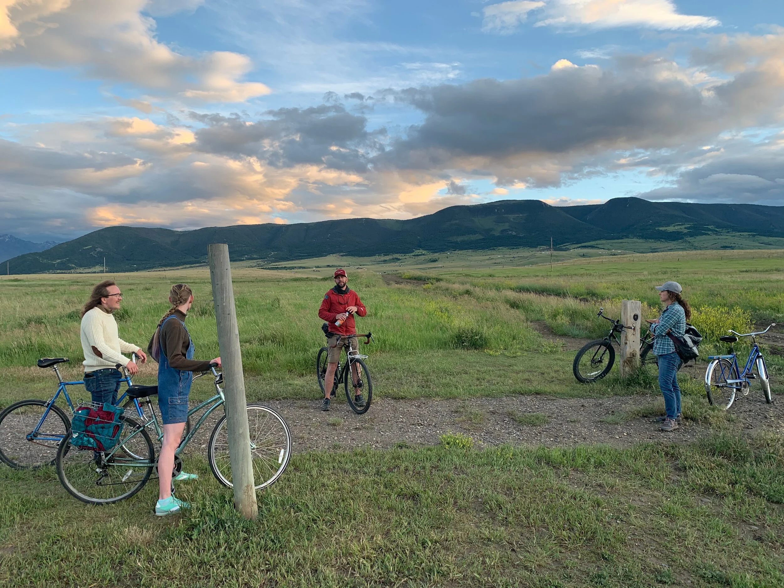
The bike auditors cruise through Green Acres on June 30.
The city of Livingston recently asked for public input on the growth policy, looking at Future Growth Areas and Extra-Territorial Jurisdiction. All proposed areas were extracted from the 2017 Growth Policy Update, which border the city and are mostly privately owned. With more questions than answers, we partnered with our local bicycle advocates, the Livingston Bicycle Club, and hit the road to see for ourselves what these areas mean to our community and the future of a bikeable city.
Our group of seven riders ranged in age from 23 to 63 years old and included representatives from several organizations including Livingston Bike Club, Park County Environmental Council, Park County Community Foundation, MSU Extension Services, Park County Health Department, and city committee and board members from Parks and Trails Committee, Tree Board, and the Conservation Board.
The team departed Lincoln High School and cycled 2.5 hours, totaling 11.5 miles to three proposed growth sections A, B and C (see Figure 1 above). We discussed each area, our riding experience to and from these areas with the perspective of safety, access, comfort and convenience, and referred to current and proposed trails in the city’s Master Parks and Trails Plan.

Bike Audit Growth Sections Route:
Stop 1 - Starting Point: Lincoln High School
Stop 2 - Section A: Green Acres
Stop 3 - Section B: North side hill
Stop 4 - Section C: Star addition
Overall
Overall, our experience demonstrated that our neighborhoods (especially the Northside) feel disconnected from one another. While they all showcase unique and positive attributes, such as feeling safe while cycling and walking while inside the neighborhood, getting to and from each neighborhood (or into town from these areas) does not feel comfortable, convenient, accessible or safe.
The Northside in general is at a larger disadvantage (in terms of walking and biking options as a mode of transportation), as this area is primarily residential with very few commercial areas. It is thus a food and economic desert, forcing residents across the railroad tracks to participate as economic and social citizens. Most do not walk or ride a bike, and are therefore dependent on a vehicle.
Crossing the tracks requires one to navigate 5th street or on the Eastside from Bennett Street over to O-Street which closely resembles role playing a game of frogger (you are the frog) as trucks and commercial vehicles speed up to 55 mph and we negotiate three lanes of unpredictable traffic. The alternative is going under the underpass (which is not an alternative if you can not wait for the train), or walking through the pedestrian tunnel. The Northside lacks safe routes to and from economic, social and recreational centers. These challenges are only exasperated when residential developments expand further from the city center without investing in mixed use development and zoning.
Our audit showed that each proposed development is between 2-4 miles away from a central point in town. If neighborhoods are isolated, what are the opportunities for walkers and bikers? If it is not safe for kids to walk or ride alone, is it practical for adults to join kids to take them to destinations outside the neighborhood? Specifically speaking about schools, if parents have more than one child (likely they are in different grades), getting kids to school is nearly impossible by bicycle – an unintended negative consequence with the one grade per school configuration.
A general feeling is that no matter what developments happen and where, they need to be interconnected. We, as a community, should have a common vision, to be building a trail network to link and bolster our current communities, “From My Neighborhood to Yours.”
While we were not able to answer all our questions (let’s face it, development takes time, time for reflection, experience and deliberation), our takeaways were irreplaceable. Compared to what we would have thought of alone at our desks, together we discovered new places, fresh insights, more questions, and engaged in thoughtful conversations and ideas that only on the ground community experiential learning provides. And did we forget to mention that we had a really fun time exploring our city doing a healthy activity?!
Reflections of each location:
Stop 1 - Starting Point: Lincoln High School
Prior to departure the group discussed bike audit perimeters, including a preferred route, some group riding safety tips, and factors that are important for a bikeable and walkable city. Factors included safety, access, comfort, and convenience, which we use in our analysis.
Stop 2 - Section A: Green Acres
Route: Lincoln School to Green Acres; Distance: 2.23 miles
From Lincoln School, we cycled down towards and along O-Street Connector, across Park Street/89 to Bennett street, turned right down Old Clyde Park Road towards Green Acres, and stopped in Green Acres Park. Our second stop and discussion was along Tana Street on the edge of Green Acres and Quizel’s private property owner and where the new service line runs. From a development perspective, with the recent annex of Green Acres and proximity to the city limits, this farmland could easily become the next spot for residential development.
Analysis
Safe:
The streets inside the neighborhood feel safe and calm with a well maintained Green Acres park central to the neighborhood
The neighborhood itself feels safe but getting to and from does not.
Bennett street to the south side of town is too dangerous for kids and some people to cross, therefore isolating the neighborhood.
Getting from the North to South side requires crossing three lanes of traffic, a turning lane, no sidewalk on either side, a narrow blind rise automobile bridge and is the beginning/end of a 55 mph 89 HWY
Accessible:
The neighborhood was new territory for a majority of bike audit participants, unless you reside here or are visiting someone.
Amenities in the neighborhood, such as a grocery or hardware store, do not exist and therefore require travel across town.
Kids that attended school and reside here are dependent on automobile travel
Sending our kids on a bike to get to school, the pool, a park outside the neighborhood is not safe.
The development is in close proximity to Livingston CBD, compared to other areas.
Comfortable:
When crossing Park Street/89 HWY - the groups felt very uncomfortable, and instead of staying together, everyone crossed differently, choosing different routes and thus becoming very unpredictable to drivers and more dangerous.
The ‘at grade’ crossing is not suitable terrain for a bicycle or walker.
The Bennett Street shoulder feels very narrow and when cars pass by riders and walkers feel exposed and vulnerable to passing vehicles.
Lack of commuting infrastructure.
Convenient:
The neighborhood feels isolated from the rest of town, therefore cycling to and from here might be primarily reserved for recreational purposes.
The location is close to O-Street connector and the hospital, as well as other natural trails, RX Coffee, and safe routes to school.
The potential to connect with other trails and the growing trail systems is high.
Options, concerns and opportunities for development:
The grid system layout works well with traffic flow, providing lots of options and fewer bottlenecks.
Mostly single family homes, the area has a need for multi-use development and homes.
The area has potential to formalize and expand green and open natural spaces, to implement the trail recommended in the Master Trail Plan, that connects all the natural northside trails and all the way to the Bozeman Connector Trail and the future railroad crossing.
Concerns revolve around the safety, access, comfort and convenience, as the location is isolated and linkages to economic and social centers non-existent
An opportunity exists to connect Green Acres to the south via O-Street, through proposed park/trail behind water treatment facility (under bridges and highway) and towards safe routes to schools, other trails and the CBD
There’s an opportunity to connect Green Acres to northside through private land (through a Quizel easement) and as per the proposed trail in Master Plan
There’s an opportunity to create safe and slow streets on E Montana Street, or using irrigation ditch networks.

Livingston’s north side has an abundance of trails that could be formalized and made into a great interconnected trail system.
Stop 3 - Section B: North side hill
Route: Green Acres to north hill (South side); Distance: 3.11 miles
From Green Acres, we rode down Tana Street toward Gallatin Street, and despite the “sharrows,” the group felt safer to explore the streets that are less crowded and where cars drove slower. Turning off onto East Montana Street, riding next to the irrigation ditch (a likely candidate for a trail that cuts through most of the Northside neighborhoods) and all the way to E Street and back to East Gallatin. Making our way to Chinook Street, we turned south onto Yellowstone Street until turning up North 7th Street towards the Northside hill. Just beyond the big hill, there’s a trail to the right, a trail that accesses the natural and undeveloped trail areas behind the residential developments of the north hill. We dismounted our bikes and pushed them up to Section B, earmarked for development.
Group reflections:
Green Acres has very few exit routes.
Gallatin Street has sharrows in the middle of the roadway, and parked cars on the side of the road prevented riding on the shoulder. Cars are driving fast, which makes the ride feel uncomfortable - riders have experienced disgruntled car drivers and people parking cars do not look when they open their doors.
New trails and areas were discovered by the group
Many informal multi use trails exist on the northside, used by bikers, runners, dog walkers, children, a herd of whitetail deer, meadowlarks and many other species.
Despite being mostly undeveloped, the trail system is a significant asset to the northside residents and used frequently.
Some bicyclists have built jumps behind the new HRDC 12-unit low/moderate-income housing and use this often.
The hill is difficult to negotiate if on a bicycle unless you cycle up and down W Montana Street, but the area lacks many other entry/exit points
Analysis
Safe:
The streets inside the neighborhood feel safe
The neighborhood itself feels safe but getting to and from does not.
Not all bicycles are conducive to using the informal trail system.
Designated trails and walking paths are not obvious and informal.
The irrigation ditch is inviting but dangerous.
Accessible:
The trails behind the northside residential areas are under utilized, and are therefore primarily used recreationally and for dog walkers and runners.
Lack of community amenities
Living up on the hill creates a barrier, with only a couple entry/exits that are dominated by cars.
Getting to and from requires the use of a car if conducting errands or shuttling children.
Comfortable:
The hill is difficult to negotiate
Cars tend to drive fast on the Yellowstone and 7th Street access points.
Lack of commuting infrastructure.
Convenient:
The neighborhood feels closer to town than the other proposed developments, yet the hill is a barrier to other aspects of town
The location is close to downtown, but AT access is not convenient.
The area near Fleshman Creek should have required setbacks in order to preserve this unique area for all to enjoy.
Stop 4 - Section C: Star addition - North Hill to Star Edition - 1.8miles (4 miles back to Lincoln High School from here)
From the northside hill (off 7th Street, between West Montana Street and West Summit Street), we pedaled South on Summit Street and turned onto the Bitterroot Trail off North 9th (0.4miles) crossing the road and making our way onto the Bozeman Connector Trail (.84miles). We stopped where the trail meets with Fleshman Creek Road, and looked out to both mountain ranges and down the gates of Paradise Valley. Surrounded by blackbird songs and water fowl roosting around us.
Group reflections:
The development has a similar feel to Gallatin County Valley residential sprawl with large expensive single-family homes, and assumed that this trend will continue in this development if nothing different is proposed.
Appears to be the fastest growing region in Livingston and feels the most distant from local economic activity.
Like the rest of the Northside, the area could benefit from mixed-use and mixed housing neighborhoods with some amenities or schools of different ages.
Birds, snakes, and other critters sharing the land and wetlands, and the group shared concerns of wildlife impact in the area.
If more development occurs and closes in on the open space, the trail will no longer be as desirable.
The wind can be quite strong and difficult to navigate yet the views are spectacular down Paradise Valley, and of both mountain ranges.
The area has a high potential to become something different and functional to Livingston culture, instead of being a bedroom neighborhood for people who work in Bozeman.
Analysis
Safe:
The streets inside the neighborhood feel safe with the central soccer fields and baseball fields.
One boulevard on Comet Street was the most appealing and inviting to bike or walk down with the central green space between both one way streets.
The neighborhood itself feels safe but getting to and from does not, especially along Front Street.
The sharrows on Front Street are hardly visible and are ineffective.
An alternative route is safe but not very convenient or comfortable and commits ones to go up and down the hill.
Accessible:
While primarily residential, not many of the group had been to the Bozeman Connector Trail.
The area is very far from town and most people would probably choose a car, creating more traffic at any current or future crossing.
No amenities, like a grocery or hardware store, and Washington School is the closest yet only for kindergarteners.
The cycle or walk is 4+ miles to town central from the end of the road and bottlenecks along Front Street.
Comfortable:
Using the Bitterroot Trail felt comfortable, however, it was not very well marked and the gravel was quite big, resulting in the trail undesirable to ride once it left the jeep track.
The grade is a bit difficult, and it is tempting to use the road towards the new development to the Northwest, or rather front street.
Front street is quite commercial with a gradual uphill that is not desirable, and feels very long and exposed.
Convenient:
The neighborhood feels isolated from the rest of town.
The trails are primarily for recreational use and are difficult to navigate by bicycle.
The trails seem to end awkwardly in places, and are less inviting than the road.
The location is close to other recreational activities, such as the soccer fields and baseball field, as well as Fleshman Creek.
The ride back to Lincoln School from the end of the Bozeman Connector was 4 miles, yet mostly downhill. We stopped along the way to review the different proposed railroad crossings and discussed which ones made sense from an AT perspective. The feeling resonated, that the further away from town you get the less likely we are to choose a bicycle or our own two legs, and the more dependent we are on our cars. We ask ourselves what is the best future we can imagine for our community?
What’s next?
Continued encouraging public process and outreach around AT topics, solutions, concerns, opportunities; emphasizing the results of the community survey and profile.
Facilitate a follow-up bicycle audit for experiential input around proposed development areas.
Integrate aspects of riding safety during our rides, it was clear that we do not all speak the same riding language which is unpredictable and creates tension for drivers.
Create opportunities to formulate a common vision, because even if growth is inevitable, we want to create something better. Stay tuned!